
The Beltany stone circle is an Irish Neolithic monument situated upon the levelled summit of Tops Hill just south of the Ulster plantation town of Raphoe in fertile east Donegal. It is one of the county’s lesser-known and less-celebrated heritage sites.

The Beltany stone circle.
A rare item of national media coverage was devoted to the stone circle in the Irish Times back in 2005; then, Eileen Battersby wrote of it in glowing terms, but with justified enthusiasm:
A short walk along a gently winding path flanked by forestry leads up a County Donegal hillside. The views of the landscape of counties Donegal and Tyrone are long and generous and include the burial mound atop Croaghan Hill. This is mythology and folklore laid open on a natural stage. At its centre is one of Ireland’s most dramatic and evocative Neolithic monuments, the Beltany stone circle.
One of five such monuments in a county rich in archaeology, and one of the finest in Ireland, it overlooks what was once the ancient territory of Magh Itha. Aloof, imposing, and profoundly spiritual, this great stone circle, once a ritual or ceremonial site, is as old as Newgrange. The 64 remaining standing stones, of an estimated original 80 or more, retain a sense of gravitas. A community chose its physical setting; subsequent generations sought its splendour. Great meetings would have taken place here. Decisions were made, disputes settled.

A section of the stone circle from within.
Whilst some sources suggest the circle may have been constructed between 1,400 BC and 800 BC, others, more recently, have claimed it was likely built before the Bronze Age, approximately 5,000 years ago. As Eileen Battersby outlined, it is made up of 64 large stones (although there may originally have been more than 80) enclosing a tumulus.
The average height of each stone is 1.8 meters, with some measuring as tall as 2.4 meters. One of the stones is decorated with cup marks. With a diameter measuring approximately 44 meters across, it is one of the largest stone circles in Ireland.

The stone circle’s lay-out (rendered by Edibobb).
The monument, traditionally known as a “druids’ circle”, is thought to have been a setting for Celtic paganist rituals and ceremonies. Mary Harte, chairwoman of the Beltany heritage group, recently outlined the significance of the site to the Strabane Chronicle (10th of December, 2015) describing it as “a sort of cathedral of the megalithic religion, the sacred place of a people who celebrated the passing of the seasons and paid homage to the gods of the sky, the sun and the moon – a sacred landscape where great ritual practices took place”.
She had previously detailed her group’s research to Donegal on the Net in 2009:
The research that we’ve carried out has led us to believe that the stone circle was a passage tomb similar to Newgrange. The monument was a passage tomb in which the cremated remains of an important person lay. It was designed so that at a particular time of the year the sun would shine down the passage and we believe that this happened in Beltany on the 21st of December during the Winter solstice.
The Chronicle did, however, make important note of the fact “that archaeologists and scholars of the period are divided over many of these stone monuments but all are agreed that they must have been of major significance both religiously and culturally in the pre-Christian era”.
The name “Beltany”, of course, is an anglicisation of the Gaelic “Bealtaine“. (Lá) Bealtaine, which has also been anglicised as “Beltony”, “Beltaine” or “Beltane” (amongst a multitude of other possible renderings and derivations) and which literally translates as “(day of the) bright fire”, was one of the four Gaelic seasonal festivals celebrated throughout Ireland, Scotland and the Isle of Man in ancient times.
Miranda Green has noted that the festival was most likely associated with the Celtic sun god Apollo Belenus (related to Baal and also worshipped under the names of Bel, Beal and Beil), as both the deity’s name and the festival’s name share the same route “bel“, meaning “brilliant light”. Thus, it is presumed Bealtaine also represents a corruption of “Baal tine“, meaning “the fire of Baal”.

A section of the stone circle from within.
Lá Bealtaine was the festival that celebrated fertility and optimism. It was connected with the waxing power of the sun and, according to the lunisolar calendar, strictly coincided with sunrise on what is now the 6th of May on our modern Gregorian calendar; this day officially heralded the beginning of summer. The festival latterly came to be celebrated on the 1st of May and its modern equivalent in the Anglophone world is commonly known as May Day.
It is thought that, as the ancient Irish congregated on this day, bonfires were lit on hilltops in a rekindling of the sun as the druids performed “great incantations” and animal herds were moved away from settlements to summer pastures.
According to the writings of the 17th-century historian Geoffrey Keating, cattle, which were a primary food source for the pastoral Celts, were, along with other domestic animals, driven between these fires so as to destroy any ticks, parasites and vermin they might potentially have been carrying; it was hoped this would have ensured the animals’ protection against possible future disease.
Local historian James Lynch subscribes to Keating’s recounting and offers the following explanatory belief as to the purpose of Ireland’s stone circles generally:
The stone circles of Ireland, and beyond, are cattle crushes or corrals, for want of a better description. The Irish of old were practical, not willing to indulge useful energy, in erecting superlative structures, rather, necessary ones. The community would come together, to complete this structure, and maintain it, and it would be on a height, for who would want smoke damage to their houses. The fires would be lit for as long as it took to have all the cattle treated, and this would take place, on one day. This was an immense effort on behalf of the ancients, and a very important one for their survival. It is recorded that the inhabitants would change and barter their horses, their arms, or what other valuables they had. The siting of the stone circles undoubtedly led them to become a place of interest and trade which would invariably continue for a long time.
The stones needed to be strong enough and tall enough to withstand large beasts in a frenzy, rubbing against them, seeking relief from ticks and heat. It’s a testimony to the builders the stones remain intact. Outer perimeter walls were necessary for the gathering-up, and cooling-off periods, for the cattle. It was compulsory for all cattle to be treated on the same day, for the remedy to be effective, and this focused type of cattle treatment, is not long dispensed with, in Ireland. Indeed I am aware, of the prosecution of two County Down farmers, for not adhering to the treatment week, in the last century.
It was a community effort, and it spared the individual farmers much effort, if each had to carry out this ritual alone. This form of treating cattle is very ancient, and would have abated on new methods of treatment being introduced ,and perhaps the incidence of ticks receding. The stone circles seem out of place, almost mystical, but their present locations should not blind us to the fact we are living many years after their use, and the locations relief was very much different in those ancient times.
In the Irish Gaelic language, the entire month of May is actually known as Bealtaine. Indeed, the Gaelic saying, “(bheith) idir dhá thine lae Bealtaine“, which literally translates as “(to be) between two May fires” and is said to have arisen from the aforementioned practice of driving cattle between fires for their preservation, has been used in common Gaelic parlance to refer to being in a state of frenzied dilemma.
Along with Lá Bealtaine, the other three annual ancient Gaelic festivals were Samhain (marking the start of winter and the origin of today’s Hallowe’en), Imbolc (celebrated in early February to mark the beginning of spring) and Lughnasadh (celebrated in early August to signify the start of autumn).

Along the perimeter of a section of the stone circle.
In common with the Newgrange monument in Meath, and as Mary Harte alluded to, there is strong evidence of astronomical alignment involving two sets of two stones that make up the Beltany stone circle. Whilst one of the alignments occurs at sunrise at the beginning of May, the other corresponds with the winter solstice. This may have aided Neolithic farmers in the area.
Boyle Somerville, a surveyor and archaeoastronomist, examined the Beltany stone circle’s astronomical significance in the early 1900s and published the following detailed description of his findings in 1923:
The somewhat rounded summit of the hill is made up (artificially) into a flat circular space, 145 ft. in diameter. The platform thus constructed is edged and defined by a circle of megaliths, of which sixty-four remain out of, possibly, an original number of eighty. The greater number are about 4 ft. high, as measured down their outer sides to the natural ground-level; while on the inner side, the tops of the stones are about level with the platform surface in the south-western part of the Circle, but stand up 1 ft. or 2 ft. clear of the platform elsewhere. There are, however, at certain points of the Circle, marked exceptions to this general height of the stones. The most noticeable of these is to the WSW., where there is a great slab, 2 ft. to 3 ft. in thickness, standing 9 ft. high, and about 8 ft. in width, in conjunction with a second considerable megalith, 6 ft. high.
Standing with one’s back to the greater of these two (which is by far the greatest stone in the Circle), and looking across the diameter on which it stands, to the ENE., one sees a large and prominent stone of the Circle, triangular in shape, with its sharp apex 4 ft. 6 in. above the Circle platform. Besides its conspicuous shape, this stone is individualized by having its whole inner surface (that facing the observer) covered with cup-markings. Continuing the line of the diameter on which it stands, there is seen beyond it against the sky, at a distance of about four hundred yards, a small but conspicuous hill-summit. This is now the site of an old windmill tower; but probably had in ancient times some sufficient indication of its purpose as a point of sight—a cairn, perhaps, or a pillar stone. The azimuth of this line, in any case, is precisely that of sunrise on Bealltaine (6th May); and it is important to note that the present name, ‘Beltany Hill’, gives the almost exact pronunciation of the Gaelic name of this ‘May Day’ celebration. This seems a very convincing proof of the connexion of the Circle with the date found by orientation.
Another orientation discoverable in this Circle is as follows. In the northwestern part of its perimeter there is another stone conspicuously greater and higher than its neighbours, though not so great as the Bealltaine-observing stone just described. It is 5 ft. 10 in. high, and about 8 ft. in width. Looking across the diameter on which it stands, the eye passes over a stone at the other end (close, to which there is growing an ancient thorn-tree) to an outlying slab, or pillar stone, 6 ft. 3 in. high, which is ‘planted’ in the ground with its longer sides parallel to the line of sight, at a distance of 67 ft. outside the boundary of the Circle. Beyond this pillar-stone, on the same line, there is a hill-summit seen against the sky, at some little distance. The azimuth of this line is (exactly) that of sunrise on the day of the Winter Solstice.
There is also an orientation across the centre of Beltany Circle to a conspicuous hill-summit named Croaghan, 3½ miles distant, crowned with an ancient earthwork, clearly seen against the sky. This line is that of sunrise at Samhuin (’All Hallows’), marking the November ‘half-quarter-day’; at six months’ distance in time, therefore, from that of Bealltaine, in May. It is unfortunate that the stones at both ends of the diameter of the Circle on this line have disappeared. The orientation should not, however, for that reason be rejected. It is not only inherently probable, but is exact in azimuth.
Yet another orientation is found in this interesting, and no doubt important, Circle by looking across a diameter from the westward over a great slab 7 ft. 3 in. high, flanked on either side by tall pillars, each about 6 ft. high, standing on the eastern edge—the three stones standing out conspicuously among their lesser neighbours. This line directs to the sharp summit of Argery Hill, two miles distant, and marks sunrise on the day of the Equinoxes (21st March and 21st September).

A plan of the stone circle drawn up in 1909 by Boyle Somerville and featured in the 1923 publication Instances of Orientation in Prehistoric Monuments of the British Isles [sic].
In latter years, archaeologist Neil Jackman further described the monument’s contemporary state for TheJournal.ie:
The interior of the site has a number of loose stones strewn around, evidence of disturbance in the past, as noted by archaeologist Oliver Davies in the 1930s. This disturbance probably dates to the nineteenth century or even earlier, as according to the OS Memoir (1836), there had been a cairn or ‘vast heap of stones’ within the circle, but it had been removed to form fences in the vicinity.
Thomas Fagan, who saw the monument in 1846, observed that both the interior and the enclosing circle of stones were ‘much disfigured’. He was informed that ‘the interior was raised with earth and stones covering and encircling sepulchral graves’ and that decayed bones were unearthed here. So it is certainly possible that this low mound in the centre is the remains of a cairn or large earth mound, and that the stone circle represents the remains of kerbing.
It has been suggested that there may have been a megalithic chamber within the circle and that the site is the remains of a passage tomb, though this has not yet been conclusively proven.
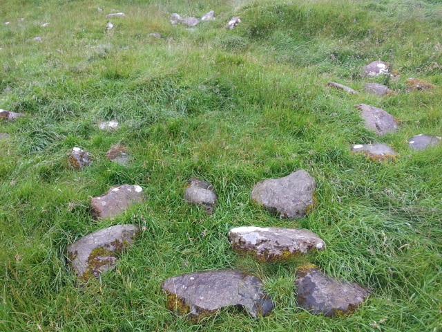
Loose stones strewn around inside the stone circle.
Although as old as Newgrange and in spite of having been assigned “National Monument” status by the southern Irish government, the enigmatic Beltany stone circle is not as nationally-renowned and remains shrouded in unmytholigised mystery.
Even many local people are unaware of its archaeological significance and possible cultural import. This is a monument deserving of greater promotion and attention.
Indeed, it is deserving of better upkeep too. Tops Hill happens to represent rather banal, nondescript modern-day countryside; or, to be more precise, a farmer’s field, either recently or periodically occupied by sheep (as is evidenced by the droppings that litter the long, unkempt grass underfoot).
The mucky entrance to the site is found after an uphill trudge through a leafy sludge of plant-litter underneath an arching canopy of overhead trees. The field in which the stone circle is located is accessed via a small, rusty swing-gate, after which one is met on their left-hand side by a small informational sign featuring out-dated information (if latest reports as to the age and believed purpose of the stone circle are reliable).
Admittedly, I visited the site on what happened to be an exceptionally wet and murky day with poor visibility in early August last – a typical Irish summer’s day, as they say – so perhaps my approach and experience was not to be as poetic or idyllic as that enjoyed by Eileen Battersby.
Nevertheless, the Beltany stone circle itself is an impressive sight that evokes poignant sentiment in respect of our nature and history as a species. Its gravity should not be understated, and especially not because of some poor Irish weather. The deep sitting mist of the perma-drizzle on the day of my visit might even have contributed to a sense of mystery in the air!
Neither do the disturbances of recent history detract from a prominent spectacle that, although “imperfect”, remains largely intact. After all, even the present-day form of Stonehenge, the world’s best-known stone circle and a UNESCO World Heritage Site, is a result of careful contemporary management and a number of large-scale restoration projects that were run at the site between 1901 and 1964, yet Stonehenge is still said to retain a sense of captivating magic for those who visit it (even if the extreme cynic might view that as a somewhat illusive experience).
The handing over of the Beltany stone circle’s care from the Department of Agriculture to the Office of Public Works a number of years ago has hopefully secured the monument’s future so it may properly flourish as a heritage landmark, although Mary Harte remains keen to assume initiative and emphasise its potential as a first-hand physical document of our rich past:
There are a lot of foreign people who visit the site especially from France and Germany, as there are similar sites on the continent. We would like more local people to visit the site and we are trying to get them interested in the site as it is something that they should be proud of as it is part of their heritage.
Post-script added on the 22nd of January, 2016: Since publishing the above account, I encountered mention of the Beltany Stone Circle in Colm Tóibín‘s 1987 book Bad Blood: A Walk Along the Irish Border. The book was Tóibín’s insight into the people and landscape along and around the border between the two jurisdictions in Ireland. He had visited the area in the mid-1980s and looked closely at the past – from inequality and subjugation to the then-ongoing “Troubles” – that haunted and divided the local people at the time.
Within that context, here is what he had to say of his visit to the stone circle in the company of his guide James Bradley, a former town clerk of Strabane:
On my map there was a reference to the Beltany Stone Circle in the Republic, a few miles beyond Lifford. The following day James Bradley drove me there. He said it was hard to find; there were no signposts, but he knew where it was. The sky was grey, but the clouds were high and moving fast with the wind. We drove beyond Raphoe and along a set of narrow roads, inadvertently passing by the turn for the stone circle once and having to double back.
Eventually, we found it and drove up a dirt track to the hill where the stones were. You could see for miles on all sides beyond the small hills to other small hills, some of them still wooded. All of them had been wooded when the stones were placed here first, around 2000 BC. The stones were big and rugged, no attempt had been made to decorate them, embellish them, or sculpt them in any way. They were jagged stones placed in a large circle at the top of this hill. This wasn’t art – this was magic.
I started to think about that moment, that second when the final stone was put in place and the circle formed. What difference it would have made to the people who placed it there: something new, powerful and complete. That there was no artifice involved, that they had merely carried them there and made them into a circle gave the stones a greater spirit. I moved around touching them, looking at the land down below. Beltany must have come from Bealtaine, the Irish word for the month of May; I said that to James Bradley. ‘No, no,’ he answered. ‘It’s even older than that, not Bealtaine, but its root Baal Tine, the fire of Ball.’ Baal was a Celtic God. Tine is the Irish for fire.
We walked down the hill, leaving the stones to their magic, aware from the reminder that there was once a time in this place where there were no Catholics or Protestants; the dim past standing there on the crown of the hill, for once a history which could do us no harm, could not teach us, inspire us, remind us, beckon us, embitter us: history locked up in stone.
Clearly, Tóibín had struck a lot luckier with the elements than I had done. Nowadays, it isn’t actually possible to drive up the dirt track to which he refers. If my memory serves me correctly, there is a bollard – definitely at least one, but perhaps two – in place at the foot of the dirt track to prevent vehicles travelling up from a tarmacced area that serves as a car-park.

Exactly the kind of post I love writing, and reading. Much more interesting than the hum-drum nonsense of contemporary politics! 😀
LikeLiked by 1 person
A lovely article, for which thank you.
Especially welcome is your reserve in interpreting precisely what this structure meant to those who built as well as to those who “used” it. Too many people, it seems to me, want to force assertively subjective dogma on prehistoric monuments that is difficult to justify by the sparce evidence that remains, not least regarding the “identity” of the builders.
It is from a much later period, but I have tried to explore this issue in relation to a stunning albeit little known site in south-east England. The video is new, though I originally wrote and published the accompanying article back in 2009:
http://thelostbyway.com/2016/05/pyramids-essex-bartlow-hills.html
I hope that you will find both text and video interesting.
Best wishes,
David Binns (London)
LikeLiked by 1 person
Many thanks for that, David. It’s amazing how little we know about many of these historic and pre-historic structures. Our need or desire to make sense of our world no doubt leads to a tendency to try and impose our own meaning or interpretation upon these things. Unfortunately, that can so often becloud rather than illuminate.
I’m glad you enjoyed my own piece of writing and I’m just watching the video on the pyramids now. Thanks for sharing it with me. I had never heard of these structures before, so it’s absolutely fascinating. Will keep an eye on the website in future. Great stuff.
LikeLike
Hi Daniel,
It is good to hear that you enjoyed the Pyramids of Essex video and that you feel it merits circulation among your contacts. Certainly you are not the only person with an interest in ancient monuments to whom those astonishing mounds are unknown. Anyway there are a couple of points I would like to make to help place my original response to your own piece in context.
First, the website where Pyramids is posted is run by writer and filmmaker John Rogers, with whom I have been working for a few months now. Several years ago I had a site of my own dedicated to prehistoric stone circles and earthworks. That might be revived at some point, but for now I am posting on a number of fronts.
Regarding Pyramids, there is a precursor which considers an Iron Age mound overlooking the River Lea at Ware, north of London. The Ware video is also posted on John’s site:
In some respects it anticipates Pyramids and develops more fully the relationship I am exploring between stone circle/mound building on the one hand and the emergence of class society and the state on the other. That – the core concept within these videos – is mentioned in Pyramids but explained more clearly, I think, in the earlier analysis.
There is something else that might interest you. Initially I was pointed to your website by a friend who sent me a link to your text on controversies concerning Jeremy Corbyn and past relationships with Sinn Fein. Then I noticed the piece on the Beltany Stone Circle, to which I responded. Only later, last night actually, did I read the Corbyn piece in detail. For sure I am impressed by the balance you maintain on issues, events and outrageous injustices that inevitably still carry an emotional charge.
Regarding the British imperial and colonial trajectory that you address there in relation to Ireland, for some three years I have been campaigning within and around the labour movement against the activities and legacy of the British ruling class and their state within Bahrain. As a retired academic I have developed this work through University and College Union, the lecturers’ organisation, in which I remain active. There is a dedicated page on my UCU branch website that has links to almost everything I have written on this struggle, from an Open Letter that I circulated in Autumn 2013 to the publication last september of an inter-union statement arising from the campaign:
http://www.ucu-retired-london.org.uk/bahrain3.html
In addition my most recent article, a report on the release from prison of Bahrain Teachers’ Association president, Mahdi Abu Dheeb, is included in our latest branch newsletter:
Click to access Newsletter-6.pdf
I have no doubt whatsoever that you will understand the relationship between my work on Bahrain and the prehistoric investigation that I am pursuing alongside it.
All best wishes, and keep up the good work.
David
LikeLiked by 1 person
Thank you for this good work. I stumbled upon this as I am writing an article about Beltany for Transceltic.com. I am humbled by your work and intend to borrow with attribution. Excellent, All the best to you. Emmett McIntyre – Transceltic.com
LikeLiked by 1 person
Thanks, Emmett. Happy you enjoyed the piece and found it helpful. Feel free to borrow. All the best to yourself.
LikeLike
[…] (Lien vers le site Web Raphoe Community in Action), (4) The Beltany Stone Circle: https://danieldcollins.wordpress.com/2015/12/17/the-beltany-stone-circle/(5) […]
LikeLike
Reblogged this on Die Goldene Landschaft.
LikeLike
Daniel, I enjoyed your compilation of the various interpretations of Beltany, including my own. Since then I have been awarded an MA in Landscape Archaeology by the National University of Ireland Galway (NUIG) , my thesis was based on Beltany and its landscape . I can suggest many things now , my research is based on factual evidence although I love to imagine what might have been too. In the 12th century it was referred to as ‘An Carn Glas’ the green mound, long before the evidence of the first OS in 1837 that noted local people saying there were ‘vast heaps of stones removed, and sepulchral graves with bones’, the stones used as field boundaries’ . So clearly this was a great burial mound probably disturbed by the farmers in the 1700s who came from Scotland in the second wave Plantation of Ulster. It was known as the ‘Druid CIrcle’ when I was growing up in Raphoe, the name Beltony/Beltany is a very recent usage from when a local man put up signs (misspelling) in this name, applied originally by Boyle Sommerville in 1909. So there is much more to be written…..I still live beside it and have done so since 1987 when Colm Tobin was there. You can still drive up the stoney path but it’s not the one you believed it to be, (the one used nowadays) …the original route way in 1987 was through the Department of Agriculture Tops Farm Yard, you can ask next time !!!
LikeLike
It’s Mary Harte….
LikeLike